 |
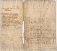
Original 1818 Town Plan of Alton by Rufus Easton |
This town plan for Alton was plotted by St. Louis resident and Missouri territory delegate Rufus Easton in 1817. He named the town in honor of his son, Alton R. Easton. This plat also shows Langdon, Alby, and George streets, which Easton likely named after some of his other children. According to writing on the plat, Rufus Easton signed and delivered the plat on January 1, 1818. It was then approved on March 26, 1818 by John T. Lusk, a justice of the peace for Madison County. There are two copies: the first is on cloth; the second on paper. The map shows the property divisions of the town, including which properties were already sold. The edge of the Mississippi River is also visible, on which the river landing is planned and a promenade set aside for common use. |
January 1, 1818 |
March 10, 2017 |

